
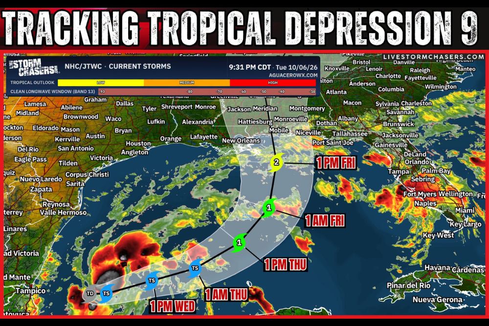
Tropical Depression 9 Expected to Become Category 2 Hurricane Isaias With 100 MPH Winds as Forecast Track Points Toward Mobile, Alabama Coast
GULF COAST — Tropical Depression 9 has formed in the southwestern Gulf and is expected to strengthen into Hurricane Isaias over the next few days. The latest forecast shows the system potentially reaching Category 2 strength with 100 mph winds before approaching the central Gulf Coast. The current track brings Isaias toward the coast near Mobile, Alabama, though the exact path and intensity can still change. Coastal Louisiana, Mississippi, Alabama, and the Florida Panhandle should begin preparations now.
Tropical Storm Isaias Expected by Wednesday
Tropical Depression 9 is forecast to strengthen into Tropical Storm Isaias by Wednesday afternoon. The system is expected to move northeast across the southwestern Gulf over the following day.
By early Thursday, Isaias is forecast to remain a tropical storm as it moves into the central Gulf. Warm waters are expected to support further strengthening during this stretch.
Isaias Forecast to Become a Hurricane Thursday
The forecast calls for Isaias to reach Category 1 hurricane strength by Thursday afternoon. It is expected to remain a Category 1 hurricane into early Friday as it moves north through the Gulf.
By Friday afternoon, Isaias could strengthen into a Category 2 hurricane with winds near 100 mph. At that point, the storm is forecast to be just south of the Mississippi and Alabama coast.
Forecast Track Points Toward Mobile
The center of the current forecast track brings Isaias toward the coast near Mobile, Alabama. The forecast cone covers a wide area from southeast Louisiana to the western Florida Panhandle.
Cities such as New Orleans, Hattiesburg, Pensacola, and Niceville fall within or near the forecast cone. Communities across this region should prepare for possible hurricane impacts.
Impacts Can Extend Far From the Center
Residents should not focus on the exact center of the forecast track. Hurricane impacts such as heavy rain, strong winds, storm surge, and tornadoes can extend well away from the center.
Areas east of the track, including the Florida Panhandle, often see the strongest winds and highest storm surge. Heavy rain could also spread far inland across Mississippi and Alabama.
Track and Intensity Can Still Change
Forecast details may still shift over the next few days as the storm organizes. Changes in timing, speed, or strength could alter where the most severe conditions occur.
Wind shear near the coast may cause some weakening before landfall. However, residents should prepare for a stronger storm and adjust plans as new forecasts are released.
Begin Preparations Now Along the Gulf Coast
Residents from Louisiana to the Florida Panhandle should gather emergency supplies, including water, food, medications, and batteries. Securing outdoor items and fueling vehicles are also important steps.
Knowing evacuation zones and routes is essential for coastal residents. Following updates from the National Hurricane Center and local officials will help ensure safety as Isaias approaches.