
Dewpoints Set to Crash Across North Carolina as Crisp, Drier Air Moves In, Bringing Much Less Humidity and Lots of Sunshine Through Friday
North Carolina – Get ready for some much less humid air. Dewpoints are set to crash tonight as cooler, crisp air moves across North Carolina. Starting tomorrow and continuing through Friday, it will feel much less humid across the state. Drier air is already moving in across the mountains, and as it spreads east, skies will clear, leading to lots of sunshine for the rest of the week.
Drier Air Already Arriving in the Mountains
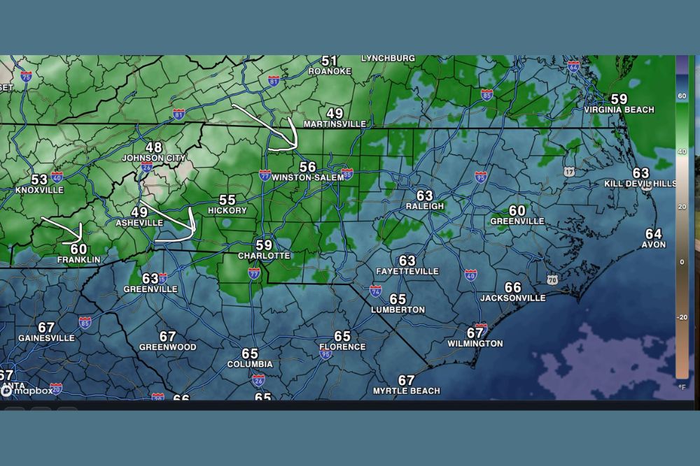
The change is already underway in western North Carolina. Current dewpoint readings show drier air pushing into the mountains and foothills from the northwest. Asheville has dropped to a dewpoint of about 49 degrees, while Johnson City, Tennessee is near 48. Hickory is around 55, and Winston-Salem is near 56.
Just north of the state line, Martinsville, Virginia has fallen to about 49, with Roanoke near 51. These lower numbers show that the drier, more comfortable air mass is steadily moving in.
Still Muggy East of the Mountains for Now
Farther east, the air is still more humid, but that will change tonight. Charlotte is currently near a dewpoint of 59 degrees, while Raleigh and Fayetteville are around 63. Greenville is near 60, and Lumberton is close to 65.
Along the coast, dewpoints remain in the mid to upper 60s. Jacksonville is around 66, Wilmington near 67, and the Outer Banks near 63 to 64, including Kill Devil Hills and Avon.
Nearby, Myrtle Beach and Columbia, South Carolina are also in the mid to upper 60s, showing how humid the air is south and east of the advancing dry air.
What Is a Dewpoint?
The dewpoint is the temperature at which air becomes saturated and moisture begins to condense. It is one of the best ways to measure how humid it feels outside.
When dewpoints are in the upper 60s and 70s, the air feels sticky and muggy. When they fall into the 50s, the air begins to feel comfortable. Dewpoints in the 40s feel crisp and dry, like a true fall day. As dewpoints crash tonight, many areas will move from muggy to comfortable, and some may even feel crisp.
Big Change Overnight
As the cooler air spreads east tonight, dewpoints are expected to drop sharply across the Piedmont, Sandhills, and Coastal Plain. By tomorrow morning, residents in places like Charlotte, Greensboro, Raleigh, Durham, and Fayetteville will likely notice a big difference when they step outside.
Even areas near the coast, including Wilmington and Jacksonville, should feel more comfortable as the drier air pushes all the way to the shoreline.
Lots of Sunshine Ahead
As the drier air settles in, skies will clear, leading to plenty of sunshine across North Carolina for the rest of the week. Clear skies and low humidity make for some of the nicest weather of the year, with comfortable afternoons and cooler nights.
Cooler Nights and Mornings
Lower dewpoints also mean cooler nights. Dry air cools off more quickly after sunset, so mornings will feel crisper than they have in recent days. Residents in the mountains may wake up to especially chilly temperatures, while areas farther east will enjoy cooler, refreshing mornings.
Anyone heading out early, including students waiting for the bus and commuters, may want to grab a light jacket.
Perfect Week for Outdoor Plans
With low humidity and sunshine on the way, this is a great week for outdoor activities across North Carolina. It is perfect weather for hiking in the mountains, visiting fall festivals, going to pumpkin patches and apple orchards, playing a round of golf, or simply opening the windows to let in fresh air.
Fall colors are beginning to develop in the high country, so it is also a good time to plan a scenic drive along the Blue Ridge Parkway.
Watch for Dry Conditions
While the dry air will feel great, low humidity combined with breezy days can increase the risk of brush fires. Residents should be careful with outdoor burning and follow any local burn restrictions.
Keep an Eye on the Gulf
While North Carolina enjoys pleasant weather, forecasters are watching a developing tropical system in the Gulf. While it is not expected to directly impact North Carolina this week, residents may want to keep an eye on updates in case moisture from the system affects the Southeast later on.
For more North Carolina weather updates and local forecasts, stay with bchssreport.com.