
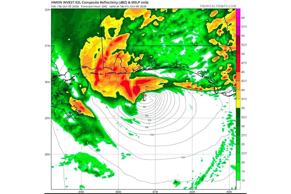
One Hurricane Model Shows Potential Isaias Making Landfall Near Pensacola as a Category 1 Hurricane Friday Evening
Pensacola, Florida – The first specialized hurricane models for Invest 92L in the Gulf are starting to paint a possible picture for the end of the week. One of those models, the HMON, shows the system developing into Hurricane Isaias and making landfall near Pensacola, Florida as a Category 1 hurricane on Friday evening. However, forecasters stress that this is just one model, and the forecast could change significantly over the coming days.
What the HMON Model Shows
The HMON hurricane model, run on Monday afternoon, October 5, shows a well-organized storm approaching the western Florida Panhandle and coastal Alabama by Friday, October 9. By early Friday afternoon, the model places the center of the storm just south of the Pensacola area, with a central pressure in the upper 970s millibars, a level often associated with a Category 1 hurricane.
The model then brings the storm ashore near Pensacola by Friday evening.
Heavy Rain Bands Across the Northern Gulf Coast
The model also shows heavy rain bands spreading well ahead of and around the storm’s center. Some of the heaviest rain is shown wrapping across coastal Alabama, including the Mobile Bay area, Gulf Shores, and Orange Beach, as well as parts of southern Mississippi and southeastern Louisiana.
Additional rain bands extend east across the Florida Panhandle, reaching toward Destin, Fort Walton Beach, and Panama City, and north into southern Alabama. If this scenario plays out, much of the northern Gulf Coast would be dealing with heavy rain, gusty winds, and rough surf by Friday.
Remember, This Is Just One Model
While the HMON scenario is eye-catching, it is important to keep it in perspective. This is only one model, and forecasts for systems that have not yet formed can shift a lot from run to run. Other hurricane models have shown slightly different tracks, with landfall possibilities ranging from eastern Louisiana to the western Florida Panhandle.
The larger global models have also disagreed on timing and track, with some taking the system north more quickly and others keeping it stuck in the southwestern Gulf for longer.
Development Chances Are High
The National Hurricane Center has given Invest 92L a high chance of development this week. If it becomes a tropical storm with winds of at least 39 mph, it will be named Isaias. If the system continues to organize as expected, it could become the first hurricane of what has been an unusually quiet 2026 Atlantic hurricane season.
Intensity Remains Uncertain
One of the biggest unknowns is how strong the system will become. The warm waters of the Gulf could help the storm strengthen, but increasing wind shear across the northern Gulf later in the week could limit how organized and powerful it gets. That is why some models show a hurricane, while others suggest a weaker tropical storm.
Even a weaker system could still bring heavy rain, flooding, coastal flooding, and strong rip currents to the region.
What a Category 1 Hurricane Can Do
A Category 1 hurricane has sustained winds between 74 and 95 mph. While it is the weakest category on the hurricane scale, it can still cause damage to roofs, siding, and gutters, bring down trees and power lines, and lead to power outages that can last for days. Storm surge and flooding rain can also be serious threats, especially in low-lying coastal areas.
Pensacola and Gulf Coast Residents Should Watch Closely
Residents in Pensacola, Escambia and Santa Rosa counties, Baldwin and Mobile counties in Alabama, and along the Mississippi and Louisiana coasts should keep a close eye on the forecast throughout the week. Even small changes in the track could make a big difference in where the worst impacts occur.
Start Preparing Now
There is still time to prepare before any watches or warnings are issued. Residents should check hurricane supplies, including water, non-perishable food, medications, flashlights, batteries, and phone chargers. It is also a good time to review evacuation zones, secure outdoor items, and make sure important documents are stored in a safe, waterproof place.
Boat owners should start thinking about how to secure their vessels, and anyone with travel plans to the Gulf Coast this weekend should stay alert to changes in the forecast.
Stay Tuned to Official Updates
The National Hurricane Center is the official source for forecasts, watches, and warnings. As the system develops and Hurricane Hunters gather data, forecasts for both track and intensity will become more reliable.
For more Gulf Coast tropical updates and hurricane season coverage, stay with bchssreport.com.