
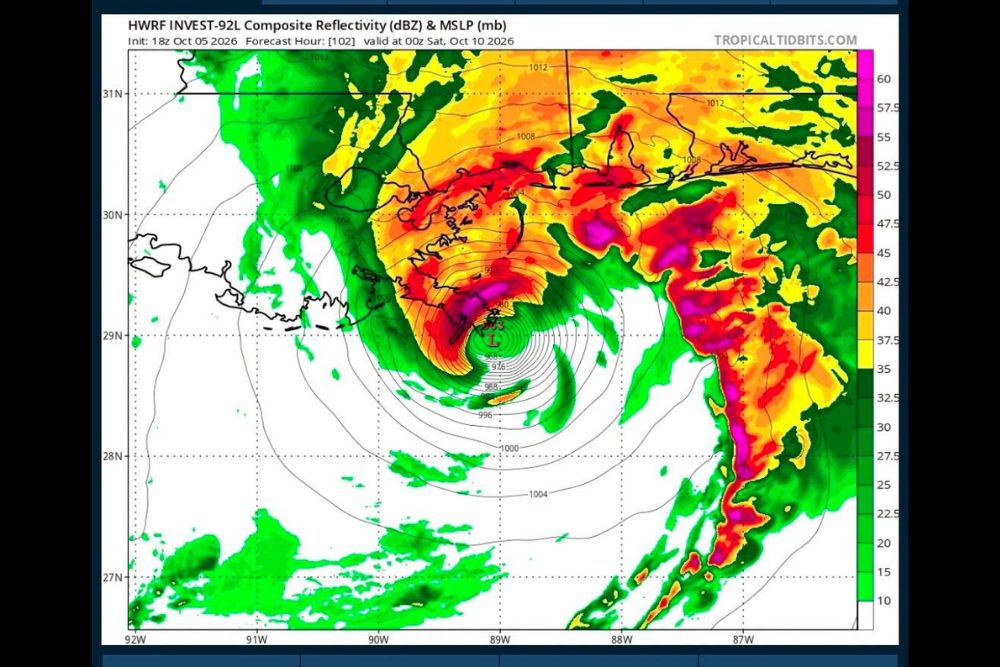
Hurricane Models Show Invest 92L Approaching the Northern Gulf Coast Between Eastern Louisiana and the Florida Panhandle Friday Into Saturday
Gulf Coast – The tropics are heating up in the Gulf. As of late Monday night, October 5, all four of the specialized hurricane models were showing a hurricane approaching the northern Gulf Coast somewhere between eastern Louisiana and the western Florida Panhandle on Friday into Saturday. The system, known as Invest 92L, was designated by the National Hurricane Center on Monday in the southwestern Gulf, and forecasters say a tropical depression is likely to form by the middle of the week.
What Is Invest 92L?
Invest 92L is an area of low pressure located in the southwestern Gulf, near the Bay of Campeche and off the coast of eastern Mexico. On Monday, it was still a disorganized trough producing scattered showers and thunderstorms, but conditions are considered favorable enough for it to slowly organize over the next few days.
An “invest” is a designation the National Hurricane Center uses when it wants to run specialized computer models and gather more data on a system. It does not mean a storm has formed yet, but it does signal that forecasters are watching closely.
Next Name on the List: Isaias
If Invest 92L strengthens into a tropical storm, with sustained winds of at least 39 mph, it would be named Isaias, the next name on the 2026 Atlantic hurricane season list. Hurricane Hunter aircraft are tentatively scheduled to investigate the system on Wednesday afternoon, which will give forecasters much better data on its structure and strength.
What the Hurricane Models Are Showing
The four specialized hurricane models run on Monday evening all showed Invest 92L developing into a hurricane before reaching the northern Gulf Coast. One of the models showed a well-defined storm with heavy rain bands sitting near southeastern Louisiana, close to the mouth of the Mississippi River, by Friday evening, with heavy rain also spreading across coastal Mississippi, Alabama, and the Florida Panhandle.
The other models showed a similar general idea, with a strong system nearing the coast between eastern Louisiana and the western Florida Panhandle sometime Friday into Saturday.
Global Models Still Disagree
While the hurricane models are in agreement, the larger global weather models are not yet on the same page. The GFS model picks up the system and slingshots it northeast toward the northern Gulf Coast by the weekend, while the European model has kept it stuck in the southwestern Gulf for a longer period.
The key question is how Invest 92L will interact with a trough over Texas. If the trough picks up the system, it could move north toward the U.S. coast more quickly. If not, the system could linger farther south.
Wind Shear Could Limit Strength
One factor that could work against strengthening is wind shear. With the jet stream dipping unusually far south for early October, strong upper-level winds are expected across the northern Gulf later in the week. Wind shear can tilt and weaken tropical systems, preventing them from becoming well-organized.
That means even if the system moves toward the coast, there is still uncertainty about how strong it will be when it arrives.
Heavy Rain Likely Either Way
Regardless of how strong the system becomes, heavy rain looks likely for parts of the Gulf Coast later this week and into the weekend. Much of the region has already dealt with soaking rain from a stalled front, and additional heavy rain could lead to flooding concerns, especially in low-lying and poor drainage areas.
Coastal areas could also see rough surf, dangerous rip currents, and possible coastal flooding if the system strengthens and pushes water toward the shore.
An Unusually Quiet Hurricane Season
This system is drawing a lot of attention because the 2026 Atlantic hurricane season has been unusually quiet. No hurricanes have formed so far this year, and September ended without a single hurricane for the first time in decades. A strong El Niño pattern has helped suppress tropical activity by increasing wind shear across much of the Atlantic.
If Invest 92L becomes a hurricane, it would be the first hurricane of the season.
Models Are Tools, Not Final Forecasts
It is important to remember that computer models are scientific tools that help forecasters understand what could happen. They are not official forecasts. Model guidance can change significantly from one run to the next, especially before a storm has fully formed.
The National Hurricane Center is the official source for forecasts, watches, and warnings. Residents should rely on its updates and guidance from local officials when making decisions.
Who Should Pay Attention?
Residents from Louisiana to the Florida Panhandle, including New Orleans, Gulfport, Biloxi, Mobile, Gulf Shores, Pensacola, and Destin, should keep a close eye on the forecast this week. People in Texas and the rest of Florida should also stay informed, since the track could still shift.
Time to Review Hurricane Plans
Now is a good time to review hurricane plans, check emergency supplies, and make sure you know your evacuation zone. Having water, food, medications, flashlights, batteries, and important documents ready before a storm threatens can make a big difference.
For more Gulf Coast tropical updates and hurricane season coverage, stay with bchssreport.com.