
Preview of Winter? Long-Range Model Shows a Deep Trough Over the Rockies by Mid-October That Could Bring Snow From the Front Range to the Black Hills
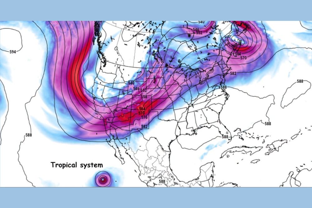
Front Range, Colorado – A preview of winter could be on the way for parts of the Rocky Mountains and Northern Plains by the middle of October. The latest run of the GFS long-range weather model shows a major trough digging into the Rockies, while a tropical system spins south of Baja California. If this pattern develops as shown, it could favor some snow along the Front Range of the Rockies and north toward the Black Hills of South Dakota.
What the Model Is Showing
The GFS model shows a powerful dip in the jet stream, known as a trough, plunging south through the western United States and into the Rockies around the middle of the month. A strong band of upper-level winds wraps around this trough, stretching from the Pacific Northwest south into the Desert Southwest before turning northeast across the Southern Plains, Midwest, and toward the Northeast.
Troughs like this allow cold air from Canada to spill south into the United States, while also creating the lift needed for storms to develop. When a deep trough sets up over the Rockies, it can bring colder temperatures, gusty winds, and snow to the mountains and nearby plains.
The Pacific Ridge Connection
Off the West Coast, the model shows a large area of high pressure, or a ridge, building over the eastern Pacific Ocean. This Pacific ridge is an important part of the setup. When a strong ridge builds off the West Coast, it often pushes the jet stream north into Canada and then forces it to dive sharply south over the western and central United States.
This pattern is a classic setup for cold air outbreaks into the Rockies and Plains, and it is often seen during the winter months.
A Possible Hint at the Winter Pattern
Some forecasters view this mid-October setup as a possible indicator of the winter pattern ahead. Early-season patterns sometimes offer clues about how the atmosphere may behave later in the year. A recurring Pacific ridge with troughs digging into the Rockies could point toward a winter with colder outbreaks and more snow chances for parts of the West and Plains.
However, long-range patterns can change, and one model run is not enough to make firm predictions about the entire winter season.
Tropical System South of Baja
The model also shows a tropical system south of Baja California in the eastern Pacific. Tropical systems in this region have been active this season, including Hurricane Polo, which sent moisture into Mexico, Texas, and the Southwest.
If another tropical system develops in this area, its moisture could potentially be pulled north into the trough over the West. That added moisture could interact with the colder air, increasing the chances for heavier precipitation, including rain at lower elevations and snow in the mountains.
Snow Possible From the Front Range to the Black Hills
If the trough develops as shown, the pattern would favor some snow along the Front Range of the Rockies, including areas near Denver, Boulder, Fort Collins, and Colorado Springs, especially in the foothills and higher elevations. Snow chances could also extend north through Wyoming, including areas near Cheyenne, and into the Black Hills of western South Dakota.
The mountains would have the best chance for accumulating snow, while lower elevations would depend on how cold the air gets and how much moisture is available.
Still Uncertainty in the Forecast
There is still some question about how the trough will evolve. Long-range models often struggle with the exact timing, strength, and location of weather systems more than a week out. The trough could end up stronger, weaker, farther east, or farther west than the current model shows.
Because of this uncertainty, it is too early to talk about specific snow totals or exact timing. Residents should treat this as an early heads-up rather than a firm forecast.
Early Snow Is Not Unusual
Snow in mid-October is not unusual along the Front Range and in the Black Hills. Many years see their first snowflakes in October, especially at higher elevations. In fact, Pikes Peak has already seen heavy snow this season, with recent storms piling up significant totals on the summit.
Time to Start Winter Prep
With winter-like patterns starting to show up in the forecast, now is a good time to start preparing. Residents can check furnaces, switch to winter tires if needed, put together a winter emergency kit for vehicles, and make sure snow shovels and ice melt are ready. Disconnecting garden hoses and protecting outdoor faucets can also help prevent frozen pipes.
Watching the Pattern Closely
Forecasters will continue watching the models over the coming days to see whether this trough and the potential for snow hold up in future runs. If the pattern stays consistent, more details will become clearer as mid-October approaches.
For more Colorado and Rocky Mountain weather updates and winter outlooks, stay with bchssreport.com.