
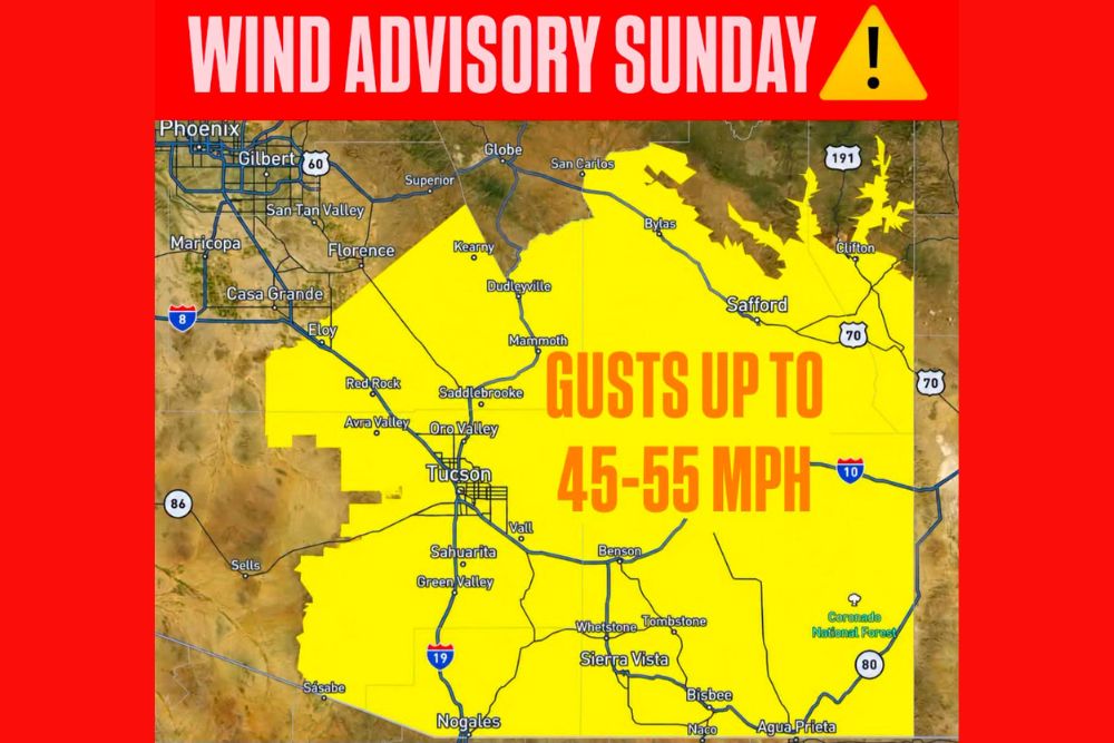
Wind Advisory Issued for Southeastern Arizona on Sunday as Strong East Winds Gust Up to 55 MPH From Tucson to Safford and the Mexico Border
Tucson, Arizona – A Wind Advisory is in effect for southeastern Arizona on Sunday as strong east winds sweep across the region. The advisory runs from 8 a.m. to 2 p.m. MST and covers a large area, including Tucson, Marana, Vail, Green Valley, Nogales, Benson, Sierra Vista, Bisbee, Douglas, Willcox, and Safford, along with the surrounding mountain areas. Sustained winds of 20 to 30 mph are expected, with gusts reaching 40 to 55 mph at times.
Where the Wind Advisory Is in Effect
The advisory covers a wide stretch of southeastern Arizona, from areas north of Tucson near Saddlebrooke, Oro Valley, Mammoth, Dudleyville, and Kearny east toward Safford, Bylas, and Clifton. It extends south across Sahuarita, Green Valley, and Nogales along Interstate 19, and covers communities in Cochise County, including Benson, Whetstone, Tombstone, Sierra Vista, Bisbee, Naco, and Douglas.
Areas along Interstate 10, from Tucson east through Benson and Willcox, are also included, along with parts of the Coronado National Forest and the region’s mountain ranges. Western portions of the advisory reach near Red Rock, Avra Valley, Eloy, and areas near Sasabe along the border.
How Strong Will the Winds Be?
Winds will blow from the east, with sustained speeds of 20 to 30 mph. Stronger gusts of 40 to 55 mph are possible, especially in mountain passes, open desert areas, and locations where east winds are funneled through valleys and canyons.
The strongest winds are expected during the morning and early afternoon hours, within the advisory window from 8 a.m. to 2 p.m.
Possible Impacts
Winds this strong can cause problems across the region. Unsecured objects, such as patio furniture, trash cans, outdoor decorations, and trampolines, could be blown around and cause damage. Tree limbs may break and fall, and some weaker trees could be knocked down.
Falling branches and strong winds could also lead to a few power outages, especially in areas where trees are close to power lines.
Dangerous Driving Conditions
Strong crosswinds can make driving difficult, especially on open highways such as I-10 and I-19. Drivers of high-profile vehicles, including trucks, RVs, vans, and vehicles pulling trailers, should use extra caution, as these vehicles are more likely to be pushed around by strong gusts.
Drivers should keep both hands on the wheel, slow down, and leave extra space between vehicles. Sudden gusts can push vehicles into other lanes without warning.
Blowing Dust Possible
In open desert areas, strong winds can also kick up blowing dust, which can quickly reduce visibility. If driving into a dust storm, drivers should follow the safety guidance to pull aside and stay alive: pull off the road as far as possible, turn off all lights, set the parking brake, and keep your foot off the brake pedal so other drivers do not follow your taillights.
Fire Weather Concerns
Strong winds combined with dry conditions can increase the risk of wildfires. Any fire that starts in grass or brush could spread quickly. Residents should avoid outdoor burning, be careful with anything that could create sparks, and never toss cigarettes outdoors. Campers and hikers in the mountain areas should be especially careful with fires.
How to Prepare Before the Winds Arrive
Before Sunday morning, residents should secure outdoor furniture, umbrellas, grills, and other loose items. Bringing smaller items indoors or tying them down can help prevent damage. Anyone with holiday or fall decorations outdoors should secure them as well.
It is also a good idea to keep phones charged and flashlights handy in case of power outages. Anyone who relies on medical equipment that needs electricity should have a backup plan ready.
Outdoor Activities
Hikers, campers, and anyone spending time in the mountains should be aware that winds could be even stronger at higher elevations. Falling branches can be a hazard on trails and in campgrounds. Boaters and anyone recreating outdoors should consider postponing activities until the winds calm down.
Winds Expected to Ease Later in the Day
The advisory is set to expire at 2 p.m. MST, and winds are expected to gradually ease during the afternoon. However, breezy conditions could linger in some areas, so residents should stay alert until conditions fully calm down.
Stay Weather Aware
Residents across southeastern Arizona should stay updated with the latest forecasts and alerts throughout the day and be prepared for gusty conditions through early afternoon.
For more Arizona weather updates and alerts, stay with bchssreport.com.