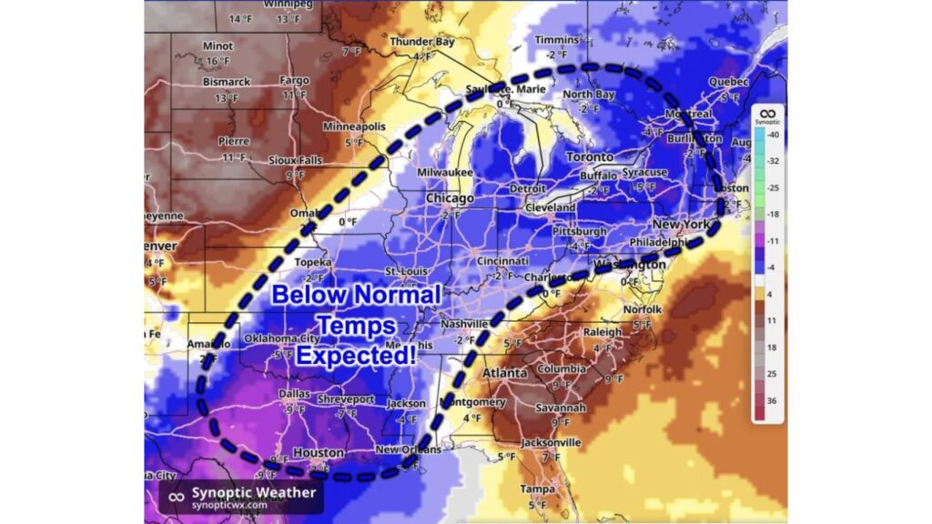
Texas, Oklahoma, the Midwest and Northeast Turn Cooler Than Normal November 6-7 as Dallas Runs 9 Degrees Below Average While the Dakotas and Southeast Stay Warm
DALLAS, TEXAS — A shot of cooler air is on the way for a large part of the country heading into next weekend, November 6 and 7, with below-normal temperatures forecast from Texas and Oklahoma through the Midwest, Ohio Valley and into the Northeast.
At the same time, the northern Plains and Southeast coast are expected to run warmer than normal, creating a sharp split across the map.
Forecast Window: Friday, November 6, and Saturday, November 7
The outlook shows how far temperatures are expected to run above or below normal across Friday and Saturday, November 6 and 7.
Coldest Departures Across Texas, Louisiana and the Southern Plains
The biggest drops below normal show up across Texas and the southern Plains:
| City | Departure From Normal |
|---|---|
| Dallas, Texas | 9°F below |
| Houston, Texas | 7°F below |
| Shreveport, Louisiana | 7°F below |
| Oklahoma City, Oklahoma | 5°F below |
| Jackson, Mississippi | 4°F below |
| Topeka, Kansas | 2°F below |
Parts of south and central Texas shade into the coldest colors on the map, with departures near 9 degrees below normal.
Midwest and Ohio Valley Run a Few Degrees Below Average
The cool air stretches north and east into the Midwest and Ohio Valley, though departures there are smaller:
| City | Departure From Normal |
|---|---|
| Chicago, Illinois | 2°F below |
| Cincinnati, Ohio | 2°F below |
| Nashville, Tennessee | 2°F below |
| Omaha, Nebraska | Near normal |
| Charleston, West Virginia | Near normal |
Northeast and Eastern Great Lakes Join the Cooldown
The below-normal zone also covers much of the Northeast and eastern Great Lakes:
| City | Departure From Normal |
|---|---|
| Syracuse, New York | 5°F below |
| Pittsburgh, Pennsylvania | 4°F below |
| Buffalo, New York | 2°F below |
| Burlington, Vermont | 2°F below |
| Washington, D.C. | Near normal |
Across the border in Canada, Quebec runs about 5 degrees below, Montreal and Thunder Bay about 4 degrees below, and North Bay and Timmins about 2 degrees below normal.
Northern Plains Stay Well Above Normal
Outside the cool zone, the northern Plains are forecast to be much warmer than usual:
| City | Departure From Normal |
|---|---|
| Minot, North Dakota | 16°F above |
| Bismarck, North Dakota | 13°F above |
| Winnipeg, Manitoba | 13°F above |
| Fargo, North Dakota | 11°F above |
| Pierre, South Dakota | 11°F above |
| Sioux Falls, South Dakota | 9°F above |
| Minneapolis, Minnesota | 5°F above |
| Denver, Colorado | 4°F above |
Southeast and Mid-Atlantic Coast Also Run Warm
Warmth also holds on across the Southeast and parts of the Mid-Atlantic:
| City | Departure From Normal |
|---|---|
| Columbia, South Carolina | 9°F above |
| Savannah, Georgia | 9°F above |
| Jacksonville, Florida | 7°F above |
| Norfolk, Virginia | 5°F above |
| Tampa, Florida | 5°F above |
| Raleigh, North Carolina | 4°F above |
| Montgomery, Alabama | 4°F above |
What the Cooldown Means for the Weekend
For areas inside the cool zone, the shift could mean:
- Chillier mornings and evenings compared to typical early November
- More need for jackets at weekend outdoor events
- Higher heating use in parts of Texas, the Midwest and Northeast
Outlook: Temperatures Could Shift as the Weekend Approaches
This forecast looks about a week ahead, so the exact strength and placement of the cool air could change. Residents should keep checking updated forecasts as November 6 and 7 get closer.
Stay with Bchssreport.com for the latest updates on this story.
About The Author
