
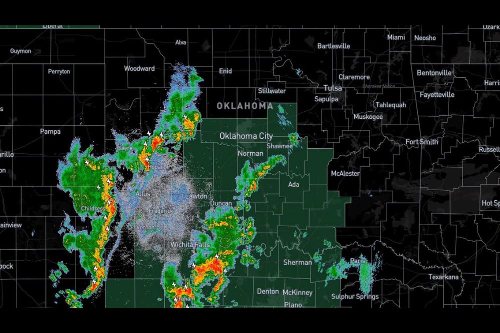
Line of Storms Pushes Across Oklahoma Overnight With 50 to 60 MPH Wind Gusts Possible, Reaching the OKC Metro Around Midnight
Oklahoma City, Oklahoma – A line of thunderstorms was organizing across western Oklahoma Wednesday night and is expected to push across the state overnight. As of 9:30 p.m., storms were lining up from western Oklahoma into northwest Texas, with the Oklahoma City metro expected to see the storms arrive around midnight before they move into eastern Oklahoma after 2 a.m. The main threat with these storms is damaging wind gusts of 50 to 60 mph, while the tornado threat remains very low for now.
Storms Lining Up in Western Oklahoma
Radar Wednesday evening showed a line of storms stretching through western Oklahoma, including areas near Sayre and Hobart, with additional storms extending north toward the area between Woodward and Alva. Frequent lightning was detected within the line, and several cells showed heavier rain and stronger cores.
Another line of storms extended south into northwest Texas, running from near Childress toward Vernon, while more storms were developing across north Texas near Wichita Falls and areas to the south. A separate band of showers and storms was also stretching from near Duncan northeast toward Shawnee, ahead of the main line.
Timeline for Overnight Storms
The storms are expected to move steadily east across Oklahoma through the overnight hours. Here is the expected timing in paragraph form for planning purposes.
Western Oklahoma will see the storms first during the evening hours, with communities near Elk City, Hobart, Altus, and Clinton already dealing with storms or seeing them arrive soon. The line is expected to reach the Oklahoma City metro, including Norman, Edmond, and Moore, around midnight. After that, the storms will continue east and push into eastern Oklahoma after 2 a.m., reaching areas like Tulsa, McAlester, and Muskogee during the early morning hours.
Damaging Winds Are the Main Threat
The biggest concern with this line of storms is strong, gusty winds. Gusts of 50 to 60 mph are possible as the storms move through. Winds this strong can bring down tree limbs, damage fences and outdoor furniture, and cause scattered power outages, especially in areas with older or weaker trees.
Residents should secure loose outdoor items such as trash cans, patio furniture, trampolines, and decorations before heading to bed tonight.
Tornado Threat Very Low
At this time, the storms are outflow dominant, which means the cool air rushing out of the storms is running ahead of the line. When this happens, it becomes harder for storms to produce tornadoes, because the rising air needed for rotation gets cut off.
Because of this, the overall tornado threat is very low. However, forecasters are still keeping a close eye on the storms, since conditions could change as the line moves into central Oklahoma, where the atmosphere may be slightly more favorable. Anyone in the path of the storms should still have a way to receive warnings overnight.
Heavy Rain and Lightning
Along with the wind, the storms will bring heavy rain and frequent lightning. Some areas could see brief downpours that lead to ponding on roads and minor flooding in low-lying areas. With deep tropical moisture from the remnants of Hurricane Polo in place across the Southern Plains this week, the storms will have plenty of moisture to work with.
Be Ready Before Going to Sleep
Since the storms will move through overnight while many people are asleep, it is important to be prepared ahead of time. Make sure your phone is charged and that emergency alerts are turned on. A weather radio is also a great way to receive warnings in the middle of the night.
It is also a good idea to know where your safe place is in your home in case any warnings are issued. Keep a flashlight nearby in case the power goes out.
Travel Safety
Anyone driving late tonight or early Thursday morning should be prepared for strong crosswinds, heavy rain, and reduced visibility. High-profile vehicles, such as trucks and trailers, can be especially affected by strong wind gusts on highways like I-40, I-44, and I-35. Drivers should slow down and watch for fallen limbs and debris on the roads.
More Rain Ahead This Week
These storms are part of a larger, active weather pattern expected across Oklahoma and Texas through the end of the week. Additional rounds of rain and storms are possible in the coming days, with heavy rainfall and flooding concerns continuing for parts of the region.
Stay Alert Overnight
While the tornado threat is low, damaging winds and lightning can still cause problems. Residents should stay weather aware throughout the night and be ready to act if warnings are issued for their area.
For more Oklahoma weather updates and storm alerts, stay with bchssreport.com.