Kansas, Oklahoma and the Midwest Brace for Big Storm to Start November as 1005 mb Low Threatens Heavy Rain, Strong Storms, Gusty Winds and Winter Weather
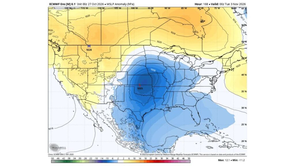
KANSAS — A big storm is looking increasingly likely to kick off November, with a low pressure system forecast to take shape over the southern Plains by Monday evening, November 2, before drifting east. Forecasters say the storm could bring heavy rain, strong storms, a broad zone of gusty winds and a winter weather side as well.
Storm Timing: Low Takes Shape by Monday Evening, November 2
The forecast shows the storm organized by 7 p.m. EST Monday, November 2 (00z Tuesday, November 3). The outlook was produced from ensemble forecast data run on October 27, looking about one week ahead.
Storm Center: 1005 mb Low Near the Kansas and Oklahoma Border
The center of the storm is placed near the Kansas and Oklahoma border, with a central pressure of about 1005 millibars.
The area of lower-than-normal pressure around it is large, spreading across:
- Kansas and Oklahoma
- Nebraska, Iowa and Missouri
- Texas and the Gulf Coast
- Arkansas, Louisiana and Mississippi
- The Ohio and Tennessee Valleys
- Much of the Southeast, including Alabama, Georgia and Florida
High Pressure Surrounds the Storm From the Rockies to Canada
Strong high pressure sits on either side of the storm:
| Feature | Location | Pressure |
|---|---|---|
| High Pressure | Idaho and Montana | 1028 mb |
| High Pressure | Eastern Canada | About 1024 mb |
| High Pressure | Off the Atlantic Coast | About 1020 mb |
| Low Pressure | Kansas and Oklahoma border | 1005 mb |
The contrast between the high pressure to the north and west and the low over the Plains is what could drive a broad corridor of gusty winds.
Main Hazards: Heavy Rain, Strong Storms, Gusty Winds and Winter Weather
Forecasters highlight four main impacts with this system:
- Heavy rain across parts of the central and eastern U.S.
- Strong storms, especially on the warmer side of the low
- A broad corridor of gusty winds spreading over a wide area
- Winter weather on the colder side of the storm
Winter Weather Side: Cold Air on the Back Edge
As the storm pulls cold air in from the north and west, the colder side of the system could bring wintry weather. The exact areas at risk for snow or mixed precipitation have not yet been determined.
Steering Currents Make the Eastward Track Hard to Pin Down
Forecasters say the steering currents guiding this storm are not easy to figure out, especially as the system drifts east after taking shape on the Plains.
That uncertainty means the exact track, strength and timing could still shift over the coming days.
Who Could Be Affected as the Storm Moves East
If the storm follows the general path shown, its effects could spread from the southern Plains toward the Midwest, Ohio Valley and Southeast early next week. Residents across these regions should keep a close eye on updates.
Preparing for an Early November Storm
To get ready, residents in the potential storm zone can:
- Secure loose outdoor items ahead of strong winds
- Clear gutters and storm drains to handle heavy rain
- Check travel plans for early next week
- Make sure weather alerts are turned on
Outlook: Details Will Sharpen as the Storm Gets Closer
Forecasters say more details will emerge in the coming days as the storm’s path becomes clearer. For now, the message is to stay alert, as November could begin with a high-impact storm.
Stay with Bchssreport.com for the latest updates on this story.
About The Author
