
Forecasters Watch the Gulf for Possible Tropical Development During the Second Week of October as Several Ingredients Begin to Line Up
Gulf Coast – The Atlantic hurricane season is not over yet, and forecasters are keeping an eye on the Gulf for the second week of October. Signals are slowly increasing that an area of low pressure could try to develop in the Gulf around that time. It is still far too early to know whether anything will become a named storm, but several ingredients that often lead to October tropical development appear to be coming together.
Early Signals in the Long-Range Guidance
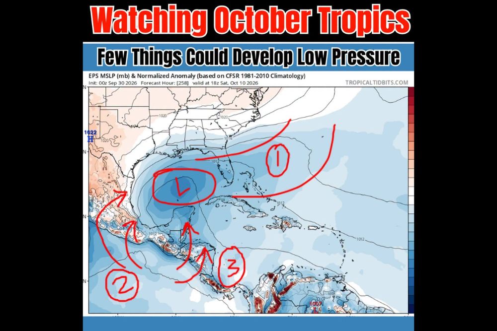
The latest European ensemble forecast, which runs dozens of slightly different versions of the same model, is showing lower-than-normal pressure over the central and southern Gulf around Saturday, October 10. When many ensemble members show lower pressure in the same area, it can be an early hint that something may try to form.
However, the main operational European model, which is the single highest-resolution run, is not showing anything noteworthy yet. That difference is a reminder that this is only an early signal, and the forecast could change significantly over the next week.
Ingredient One: An Old Front That Lingers
The first factor is an old cold front that is expected to push into the Gulf and the waters near Florida several days before the possible development. Instead of clearing out completely, the front could stall and linger across the region.
Stalled fronts over warm water are a common starting point for tropical development in October. The leftover boundary can provide a focus for showers, storms, and spin, especially when the water beneath it is still warm from the summer months.
Ingredient Two: Pacific Moisture Crossing Into the Gulf
The second factor is moisture from the eastern Pacific. Forecast guidance suggests that some of this Pacific moisture could cross over Mexico and Central America and get pulled into the Gulf.
This has already been an active season in the eastern Pacific, with Hurricane Polo sending tropical moisture into Mexico and the southern United States. Additional moisture moving across from the Pacific side could help add fuel to any low pressure that tries to form in the Gulf.
Ingredient Three: The Central American Gyre
The third factor is a large-scale feature known as the Central American Gyre, often called the CAG. This is a broad, slow-turning area of low pressure that tends to develop over Central America and nearby waters, especially in late spring and fall.
The gyre itself is not a tropical storm, but it can act like a nursery for tropical systems. Smaller areas of low pressure can form within or along the edges of the gyre and sometimes drift north into the Gulf or the western Caribbean, where they may strengthen if conditions allow.
Ingredient Four: October Climatology, El Niño, and the MJO
The fourth factor is history. In October, tropical development often shifts closer to home, with the Gulf and western Caribbean becoming the most common areas for storms to form. Many memorable October storms have developed in these areas.
This year, an El Niño pattern is also in place, which tends to bring more wind shear to parts of the Atlantic and can limit storm development. However, El Niño years often see more activity focused near the Gulf and western Caribbean late in the season. Forecasters are also watching the Madden-Julian Oscillation, or MJO, a large pattern that moves around the globe and can temporarily boost rising air and storm activity in certain regions. If the MJO lines up favorably during the second week of October, it could help support development.
Named Storm or Not? Too Early to Know
At this point, it is too early to say whether this possible low will become a tropical depression, a named storm, or simply a broad area of rain. Forecasts this far out are always uncertain, and early signals can fade just as quickly as they appear.
What forecasters can say is that the pattern deserves attention. Even without becoming a named storm, a low pressure system in the Gulf could still bring heavy rain, gusty winds, and rough surf to parts of the Gulf Coast and Florida.
Who Should Pay Attention?
Residents along the Gulf Coast, including Texas, Louisiana, Mississippi, Alabama, and Florida, should keep an eye on the forecast over the next week. People in Mexico’s Yucatán Peninsula and nearby areas should also stay alert, since moisture and low pressure may develop close to that region.
Hurricane Season Is Not Over
Hurricane season officially runs through November 30, and October can still produce strong storms. Now is a good time for residents in hurricane-prone areas to review their plans, check emergency supplies, and make sure they know their evacuation zones, especially after an active stretch of weather in recent weeks.
More Updates Ahead
As the second week of October gets closer, forecast models will come into better agreement on whether anything develops. Residents should check back for updates as forecasters continue to monitor the Gulf.
For more tropical weather updates and hurricane season coverage, stay with bchssreport.com.