
Remnants of Hurricane Polo Spread a Wide Shield of Rain Across the Central Plains and Midwest, a Setup That Would Have Meant a Major Winter Storm in January
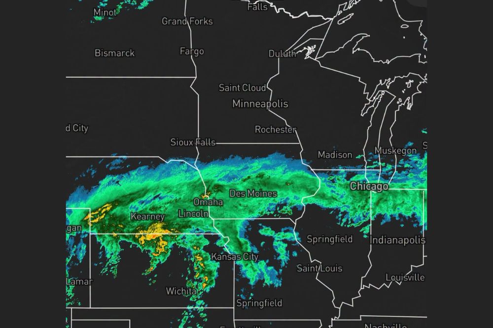
Midwest – The remnants of Hurricane Polo have arrived in the central United States, spreading a broad band of rain from the Central Plains all the way into the Midwest. Radar shows a long, steady rain shield stretching across Nebraska, Kansas, Iowa, Missouri, Illinois, and Indiana, reaching cities like Omaha, Lincoln, Des Moines, Kansas City, and Chicago. With a storm this large and moisture-rich, many weather watchers are pointing out that if this had happened in January, it would have been a big winter storm.
From the Pacific to the Heartland
Polo began as a powerful hurricane in the eastern Pacific Ocean before making landfall in Mexico. While the storm’s winds weakened quickly over the mountains, its deep tropical moisture did not disappear. That moisture was pulled northeast into the Southwest and Southern Plains, where it fueled heavy rain and flooding concerns across Texas, Oklahoma, New Mexico, and Colorado.
Now, that same moisture has been swept up by a larger weather system and carried into the Central Plains and Midwest, creating a wide area of rain stretching for hundreds of miles.
A Long Band of Rain Across the Plains and Midwest
Radar shows the rain shield extending from western Kansas and Nebraska eastward through Iowa and northern Missouri, then continuing into northern Illinois and northern Indiana. Cities along this path, including Kearney, Lincoln, Omaha, Des Moines, Kansas City, and Chicago, are all seeing rain.
The northern edge of the rain stretches near Sioux Falls and toward southern Wisconsin, including areas near Madison, while the rain also reaches the Lake Michigan shoreline near Muskegon. To the south, areas around Springfield, St. Louis, Indianapolis, and Louisville sit closer to the southern edge of the rain or stay mostly dry for now.
Heaviest Rain in Nebraska and Kansas
Some of the heaviest rain on radar is falling across south-central Nebraska and northern Kansas, where pockets of moderate to heavy rain are showing up near Kearney and areas to the south. Additional heavier cells were developing farther south across central Kansas toward Wichita, with scattered storms also showing up near Kansas City.
Farther east, the rain across Iowa and Illinois looks more steady and widespread, with lighter to moderate intensity. While the rain there may not be as intense, the long duration could still add up to meaningful totals.
Why It Would Have Been a Big Winter Storm
The comparison to a January winter storm comes down to the size and moisture of the system. In early October, temperatures are still warm enough for this moisture to fall as rain. But in the middle of winter, when much colder air is in place across the Plains and Midwest, a storm with this much moisture and this large of a footprint could have dropped heavy snow across a wide area.
A rain shield stretching from Nebraska to Indiana would likely have meant several inches of snow or more for many communities, along with travel problems, school closures, and possibly blizzard conditions in windy areas. Instead, the region is getting a soaking rain, which is far easier to deal with.
Welcome Rain for Many Areas
For many parts of the Plains and Midwest, this rain is welcome news. After a warm and dry stretch heading into fall, the moisture will help improve soil conditions, recharge ponds and streams, and give lawns and gardens a boost. Farmers in the middle of harvest season may see some delays, but the rain could also help with soil moisture heading into next year’s planting season.
Travel Impacts Possible
With rain falling across major travel corridors, drivers should be prepared for wet roads and slower travel. Interstates such as I-80 through Nebraska and Iowa, I-35 through Kansas and Iowa, and I-88 and I-90 in northern Illinois could all see reduced visibility and slick conditions. Air travelers flying through Chicago, Omaha, Des Moines, and Kansas City may also want to check for delays.
Watch for Localized Flooding
While widespread flooding is not expected across most of the Midwest, areas that see repeated rounds of heavier rain could deal with ponding on roads and minor flooding in low-lying or poor drainage areas. Drivers should avoid driving through water-covered roads, especially at night when depth is harder to judge.
A Sign of the Season Ahead
Storms like this are a reminder that the cold season is coming. As temperatures continue to drop through October and November, similar systems moving through the Plains and Midwest will have a better chance of producing snow. Weather watchers will be keeping a close eye on how active the pattern stays as winter gets closer.
For more Midwest weather updates and storm coverage, stay with bchssreport.com.