Alabama, Georgia and Tennessee Watch for Strong Storms by Wednesday Night, November 4, as Weekend Rain Ends Long Dry Spell and Tornado Season Begins
ALABAMA — A major pattern change is on the way for Alabama, where a long dry spell is set to end this weekend with the best rain coverage on Sunday. A stronger, more dynamic storm system could follow by the middle of next week, bringing the potential for strong to severe thunderstorms right as Alabama’s tornado season begins.
Dry Spell Ends: Rain Returns to Alabama This Weekend
After weeks of mostly dry weather, rain chances finally return to Alabama this weekend. The highest coverage of rain is expected on Sunday, November 1, giving much of the state its first meaningful soaking in some time.
Alabama Tornado Season Begins Sunday and Runs Through May
Sunday also marks the official start of Alabama’s tornado season, which runs from November through May. Fall and winter storm systems can bring severe weather to the state, making this a key time for residents to review safety plans.
Midweek System Could Bring Strong to Severe Thunderstorms
Forecasters are watching a more dynamic system expected to arrive by the middle of next week. It might offer the potential for strong to severe thunderstorms.
It is still too early to know specific details such as timing, location or intensity, so this is simply something to watch for now.
Upper-Level Pattern: Deep Trough Digs Into the Central United States by Wednesday Night
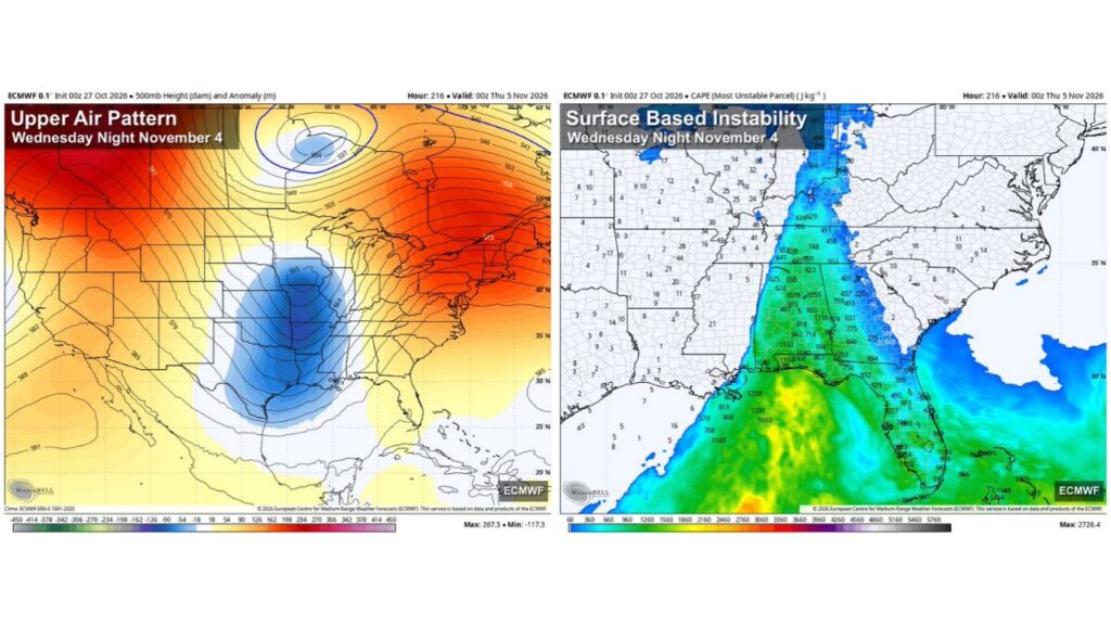
Forecast upper-air maps for Wednesday night, November 4, show a deep trough of low pressure centered over the central United States, stretching across:
- Oklahoma
- Kansas
- Missouri
- Arkansas
- Texas and the western Gulf Coast
At the same time, ridges of high pressure sit over the western states and the Northeast, with another low spinning far to the north in Canada. This setup places the Southeast in the path of energy moving east from the central U.S.
Instability Builds From the Gulf Into Alabama, Georgia and Tennessee
Forecast surface instability for Wednesday night shows a band of energy stretching north from the Gulf of Mexico through the Southeast:
| Area | Forecast Instability (J/kg) |
|---|---|
| Gulf of Mexico | About 800 to 1,668 |
| Southern Alabama | About 1,000 to 1,314 |
| Central Alabama | About 600 to 1,116 |
| Western Georgia | About 400 to 1,050 |
| Florida Panhandle and Peninsula | About 400 to 1,000 |
| Tennessee | About 400 to 850 |
| Kentucky | About 100 to 640 |
The highest values over land show up across Alabama, where readings top 1,000 J/kg in several spots.
Mississippi and Louisiana Sit on the Western Edge of the Instability
West of Alabama, instability values drop off sharply. Much of Mississippi, Louisiana and Arkansas shows very low values, placing the main zone of energy from Alabama eastward.
Hazards to Watch: Strong Winds and Severe Storms Possible
If the midweek system comes together as forecast, possible hazards could include:
- Strong to severe thunderstorms
- Damaging wind gusts
- Heavy downpours in stronger storms
Any tornado threat is not yet clear at this range and will depend on how the system develops.
Forecast Confidence Remains Low More Than a Week Out
These maps look roughly nine days ahead, so details are likely to change. Small shifts in the storm’s track, strength or timing could make a big difference in which areas see severe weather.
Impact: Rain Relief Followed by a Possible Severe Weather Test
The weekend rain should bring welcome relief to dry soils, lawns and gardens across Alabama. The midweek system, however, could serve as an early test of severe weather readiness in the first week of tornado season.
Outlook: Prepare Now and Watch Forecast Updates
Residents across Alabama, Georgia, Tennessee and the Florida Panhandle should:
- Review tornado and severe weather safety plans
- Make sure weather alerts are turned on
- Check updated forecasts through the weekend and early next week
Stay with Bchssreport.com for the latest updates on this story.
About The Author
