
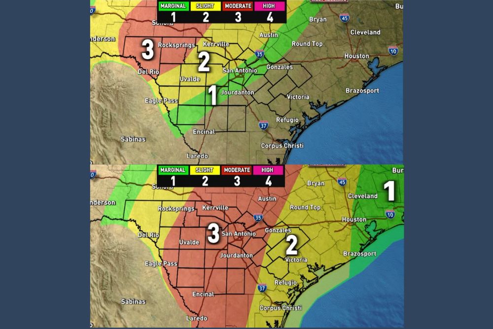
South Central Texas Faces a Multi-Day Flood Threat as Level 3 of 4 Risk Covers San Antonio and the Hill Country With 2 to 8 Inches of Rain Possible
San Antonio, Texas – A significant flooding rain event is taking shape across South Central Texas over the next three days. Excessive rainfall outlooks show the threat starting across the western part of the region on Wednesday, before expanding to cover most of the area with a Level 3 of 4 risk from Thursday through early Friday. By the time the rain ends, widespread totals of 2 to 5 inches or more are expected, with 6 to 8 inches or more possible in the heaviest pockets.
Understanding the Flood Risk Levels
Excessive rainfall outlooks use a four-level scale to show the risk of flash flooding. Level 1 (Marginal) means isolated flooding is possible, Level 2 (Slight) means scattered flooding is possible, Level 3 (Moderate) means numerous flash flood events are likely, and Level 4 (High) is reserved for widespread and severe flooding situations.
A Level 3 of 4 risk is a serious signal. It means forecasters expect flooding to be more widespread and potentially dangerous, especially in areas prone to fast-rising water.
Wednesday to Early Thursday: Western Areas First
The first round of heavy rain will focus mainly on the western third of the region from Wednesday into Wednesday night. A Level 3 of 4 risk is in place for areas around Del Rio, Rocksprings, and Sonora, where the heaviest rain is expected to develop first.
A Level 2 of 4 risk extends east across Kerrville, Uvalde, Eagle Pass, and the San Antonio area, while a Level 1 of 4 risk reaches areas near Jourdanton and along parts of the I-35 corridor. Areas farther east, including Gonzales, Victoria, and Houston, are not expected to see much of a flood threat during this first period.
Thursday to Early Friday: The Main Window
The main window to watch is Thursday through early Friday, when the heaviest and most widespread rain is expected. During this period, a Level 3 of 4 risk covers most of the region, including San Antonio, Kerrville, Uvalde, Del Rio, Rocksprings, Jourdanton, Eagle Pass, Encinal, and Laredo.
A Level 2 of 4 risk extends farther east across Gonzales, Victoria, Refugio, and Corpus Christi, while areas closer to Houston, Brazosport, and Cleveland fall under a Level 1 risk. This is when rainfall totals are expected to climb quickly, and when flash flooding will be most likely.
Friday to Early Saturday: Lingering Threat
A lingering Level 2 of 4 risk will remain in place on Friday, especially during the first half of the day. This risk covers much of the western and central part of the region, including San Antonio, Kerrville, Uvalde, Del Rio, and parts of South Texas. Areas to the east, including Gonzales, Victoria, and Corpus Christi, fall under a Level 1 risk.
Forecasters will also be watching to see if a few more downpours develop Friday night into early Saturday. Because the ground will already be saturated by then, even moderate rain could cause additional flooding problems.
How Much Rain Could Fall?
By the time this event wraps up, widespread rainfall totals of 2 to 5 inches or more are expected across the region. In the heaviest pockets, totals could reach 6 to 8 inches or more. Where storms repeatedly move over the same areas, rain could pile up quickly, leading to rapid rises on creeks, rivers, and low-water crossings.
What Is Fueling the Heavy Rain?
The setup is being driven by a combination of deep tropical moisture, including leftover moisture from Hurricane Polo, along with moisture from the Gulf and a slow-moving upper-level storm system. Together, these ingredients create an atmosphere loaded with moisture, capable of producing very heavy rainfall rates in a short amount of time.
Hill Country Flooding Concerns
The Texas Hill Country is especially vulnerable to flash flooding. Steep terrain, rocky soils, and narrow river valleys allow rainwater to run off quickly and funnel into creeks and rivers. Areas around Kerrville, Rocksprings, and Uvalde can see water levels rise dramatically in a short period of time, sometimes within minutes.
Residents living near rivers, creeks, and low-lying areas in the Hill Country should pay close attention to local alerts throughout the event.
Turn Around, Don’t Drown
The biggest danger during flash flooding is driving into flooded roads. Many flood-related deaths in Texas happen when drivers try to cross low-water crossings or water-covered roads. Just 12 inches of moving water can carry away most cars, and 2 feet can sweep away larger vehicles, including trucks and SUVs.
If you come across a flooded road, turn around and find another route. It is impossible to tell how deep the water is or whether the road beneath has been washed away.
How to Prepare Now
Residents should take time before the heaviest rain arrives to prepare. Clean gutters and storm drains, move vehicles and valuables away from flood-prone areas, charge phones and backup batteries, and make sure emergency alerts are turned on. Anyone living in a flood-prone location should have a plan for where to go if water begins to rise.
Stay Alert Through the Weekend
With multiple days of heavy rain expected, conditions could change quickly. Residents across South Central Texas should monitor forecasts and warnings closely from Wednesday through early Saturday and be ready to act if flash flood warnings are issued.
For more Texas weather updates and flood alerts, stay with bchssreport.com.